Walks Programme
- A Map of South Wales showing where we walk within South and Mid Wales, can be found here.
- A list of the all the Areas We Walk in Wales and England can be found here, and information on our walk grading system is found here.
Click on a link to find out further information on a day walk or weekend away. Most walks have links to 1:50000 Ordnance Survey Landranger maps of the area.
Winter Term
- August 2012
- Saturday 29th - Three Cliffs Bay
- October 2012
- Sunday 7th - Fan Fawr
- Friday 12th - Dorset Weekend Away
- Saturday 20th - Lord Hereford's Knob
- Sunday 28th - Preseli Hills
- November 2012
- Sunday 11th - Pen y Fan
- Sunday 18th - Gower Free Walk
- Saturday 24th - Glamorgan Heritage Coast
- Friday 30th - Dartmoor Weekend Away
- December 2012
Spring and Summer Term
- January 2013
- Sunday 27th - Swansea Gower Walk
- February 2013
- Saturday 2nd - Usk Reservoir
- Friday 8th - Rhinogs Weekend Away
- Saturday 16th - Pen Allt Mawr
- March 2013
- Saturday 2nd - Bannau Sir Gaer
- Sunday 10th - Rhossili to Port Eynon
- Sunday 17th - TBC
- Friday 22nd - Snowdonia Long Weekend Away
- April 2013
- Saturday 20th - Vice's Variable Vacation
- Sunday 28th - Ystradfellte Waterfall Walk
- May 2013
- Saturday 4th - Amroth to Tenby
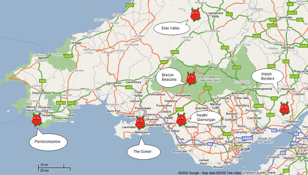
Map of South Wales
This is a map of South Wales marked by helpful red dragons to show where the areas we go are in this country. Click on the little red dragons or on the region to go to the walks page.
Links to these walks pages and the other places we go are also listed below.
Areas we walk in
Here are links to the pages describing the areas that we have walked in:
Wales
- Brecon Beacons
- Elan Valley
- Gower
- Neath and Glamorgan
- Pembrokeshire
- Snowdonia
- South East Wales and Welsh Borders
England
Walks Grades
For safety and so that everyone knows what they are getting themselves into, all walks are graded. Everytime a walk is advertised it will be stated whether it is an A, B or C distance walk and a 1,2 or 3 difficulty walk.
Distance
- A - Less than 8 miles (under 12.5km)
- B - 8 - 12 miles (12.5 - 19km)
- C - Longer than 12 miles (more than 19km)
Approximate height gain
- 1 - Less than 200 metres
- 2 - 200-500 metres
- 3 - Greater than 500 metres
If you are unsure of your ability, it is advisable to do a "A" walk before a "B" walk and a "B" walk before a "C" walk.
In any case, the walks marked with a * cannot be done before you have complete at least a "B" walk.